
Mt. Erciyes
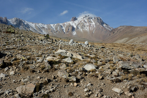
Mount Erciyes, an extinct volcano, sits on the surrounding desert plain as though dropped directly from the French Alps. It is simply out of place. The grey, rocky, snow-capped peak is uncontested amongst the yellow, rounded, dusty hills which sit around its base.
I had vaguely planned on heading ten hours east to Diyarbakir, but when Tony mentioned a peak at 3917m just outside of Kayseri, an hour’s coach ride from Cappadocia, I snapped-up the chance. I wasn’t ready to leave behind the outdoors quite yet. The coach ride gave us our first glimpse of the mountain; beforehand we knew little, except that it was a decent altitude and accessible. Negotiating our way from the shiny, new Otogar to Kayseri’s centre, we reasoned that the village of Hacılar seemed like a reasonable point at which to base ourselves for the ascent. Arriving in Hacılar by bus, we were far from inconspicuous with our backpacks, and lost look. Within a minute or so, a couple of local lads approach us, asking us in Turkish what we are looking for. A few minutes later, we are at the centre of a dozen people, a couple of whom spoken very, very broken English. Despite living under the shadow of Erciyes, they didn’t seem to know how we could access the approach, estimates coming between ten and twenty kilometres away. I was passed a mobile phone where I was told we would need a guide, map, axes, cramp-ons, and we have to register with the police. One thing they could agree on was that there were no hotels or places to stay in Hacılar.
Cue a bus-trip back to Kayseri.
Just before we left, we stumbled across a French girl who had just moved to the region to be with her Turkish husband, who just happened to be a mountain guide. His services were way out of our budget, but we did manage to find out that from Kayseri, we could take a bus in the direction of Develi and get off at a little ski-resort which sits at the bottom of the mountain.
The next day, after a thirty minute minibus ride, we were at 2100m, looking for a hotel in the collection of buildings which goes by the name of Erciyes, excited by the prospect of what this mountain had in store for us. Wandering around, we were stopped by the military, who operated a check-point on the pass, and instructed that if we wished to climb the mountain, we would have to bring our passports to them. We’ll climb tomorrow, we told them, offering to register the next day as their massive guns hung across their chests.
Noon was fast approaching by the time we stepped out to the mountain, so today would just offer enough time for a reccie. We walked up the snow-less pistes to get a better view of the ridge which would offer passage to the summit. Here, we were alone with the mountain. We soon passed the point after which the military required declaration, but thought to just rise a little further. We had no food, no water, and were just wearing light clothes; we hadn’t intended a big climb today. An hour later, I was clutching at the crumbling rock on a rocky ridge, the years of freeze-thaw rendering it brittle, it breaking away as I moved. Things were getting a little sketchy as we passed the snow-line.
At around 3700m, with only a very sketchy climb separating us from the peak, we decided to hold-off until the next day, and tentatively made our way back down the craggy rock, before a 500m descent of scree running.
Once back down we registered with the military, not wanting to waste time in the morning: we’d need an early start. They warned us of the “glacier” on the approach to the summit, and looked worried as we told them we had neither axes, cramp-ons, nor a map or telephone. They also laughed-off our estimate of reaching the top of the chair-lifts in less than an hour. (We’d done it in 45 minutes this morning, but hesitated making reference to today’s ramble.) Our details were written in the log-book, along with estimated return times (which again, they thought laughable) and we noticed that it had been quite a while since they’d seen other people heading for the summit.
Our planning was less than ideal: daylight-savings had just knocked-off an hour evening light, we had little gear and no map. These points, however, weren’t what kept us from a good night’s sleep; it was excitement that kept me awake.
We started off early, and had reached the bottom of the ridge in about an hour. The ridge was drowning in sunshine on its southern face, and the shaded, northern face harbouring shadows and snow. The wind up here brought the temperature down on my perspiring body, and I was glad of the beanie I’d bought in Göreme.
After reaching the top of the first ridge, at around 3600m, we had to cut back down, around a massive rocky outcrop. This involved traversing an icy snow-field, which threatened to take us back down to the bottom of the valley. Coming up to the other side, we were offered magnificent views of the barren plains below, the odd volcano dome rising up, reminding you of how this landscape was formed.
A scree-climb reminds me that my fitness leaves a lot to be desired, particularly with the altitude twisting its knife in my side. The summit is within site, and only a snow-covered, steep-sided ridge separates us from our goal. From a distance, we questioned whether we should attempt it, but getting closer, it was hard to refuse. Several minutes later we had views of Kayseri’s high-rises to the north, and the volcanic plains to the south. A pillar of rock, scarred with the cracks of constant freeze-thaw action, crowns the mountain. I am exhilarated.
The rocky, scree covered descent, which we opt-for slices open my fingers as I slide down, but they are already numb from the cold so the pain is preserved for later.
We arrive back, an hour and a half earlier than expected, and the military welcome us with çay. I’m not sure if they’re happy to see us because they don’t get many visitors up here, during their National Service; it makes a change to see foreigners; or just because it means they won’t be dragged onto the mountain to rescue the naïve English- and French-men. Whatever they’re reason, they’re keen to have their photo taken with us.
Several hours later, we are waiting for the bus in Kayseri to take us to Kahta, a short trip away from Mt. Nemrut.
(More photos here on Facebook, courtesy of Tony…)